Recently discovered evidence from Egypt supports the theory that south west Iberia is the remnant of Plato´s Atlantis.
In my book, ALANTIS and the Silver City, published in 2013, I listed all the clues from Plato´s dialogues about Atlantis that we could still possibly hope to identify today and then proved that all 60 matched southwest Iberia and north Morocco. My conclusion was confirmed by the perfect fit of a unique site for the ancient capital. Plato gave so many exacting and precise details for this city it completely ruled out duplication by mere coincidence. The site is where the Algarve city of Silves stands today. It fits the unique geological and geographical template that Plato described.
Nevertheless, the world´s media did not even bother reporting or commenting upon it, despite consistently gorging on the most outrageous stories about Atlantis. The latest examples being the report of the discovery of the mysterious Atlantis metal, Orichalcum, and that Sardinia was Atlantis. It only needed a cursory reading of Plato to have discovered that both claims were farcical. If you do not twist, distort, try to second guess what Plato wrote, or omit whole passages to suit outlandish theories (such as for Santorini and other Mediterranean sites) it is abundantly clear where he was referring to. It has been under our noses all along. It stretched from Gibraltar to Cape St. Vincent in Portugal, plus the north coast of Morocco. But more particularly part of what is now the seabed between these two regions which sank in the great cataclysm that Plato said engulfed Atlantis. Similar seismic upheavals of huge proportions have continued to afflict the region every 1200 to 2250 years, the last in 1755.
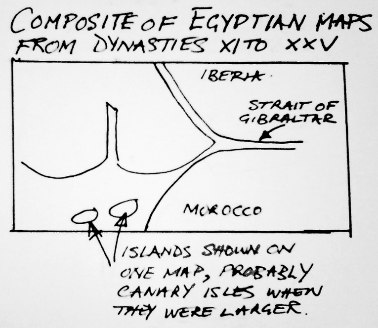
Now, a Spanish researcher, Georgeos Diaz Montexano, has unearthed critical supporting evidence that verifies my theory. He has discovered ancient simplified maps on various Egyptian Papyri that although spanning many dynasties, depict the same image. The maps are quoted as being of Amenti, in an immense infinite cold sea in the remote west, and the entrance to it through a narrow stretch of water. In other words, the Atlantic, reached via the straits of Gibraltar.
But these maps show a large landmass sitting just outside the straits that is not there now. (See Illustration below)
Further confirmation that the maps depict the Atlantic is that the climate of that part of south west Iberia which is in the Atlantic is very much the same as the Mediterranean but with one notable difference. In the Mediterranean the sea is relatively warm but in the Atlantic it is cold even in the middle of summer, a distinction that the Egyptians thought important enough to point out.
Amenti was the Egyptian land of the dead, quite befitting a place where hundreds of thousands of people would have almost instantaneously perished in a broiling sea as their homeland sank beneath their feet. Khenti-Amenti was also their name for the God Osiris, described as the “Foremost” or “The chief of the Westeners”, who had had Kingship in the land of the dead.
In my book I had suggested that long sandbar islands and lagoons that are now not far off the Spanish and Algarve coasts could be the remnants of a combination of a strait of water that once separated, or partially separated, the mainland from another landmass which has now sunk to form seabed. Indeed, an updated translation of what Plato actually wrote, taken from a fragment of the original ancient Greek rather than a later Latin translation, suggests he referred to another strait outside the straits of Gibraltar when talking of mud shoals. These ancient Egyptian maps which existed long before Plato, show just that. They depict the strait of Gibraltar extending much further into the Atlantic and then splitting into two straits, one flowing northwest in front of the Iberian coast and the other southwest in front of Morocco. They separate the two mainlands from an island like landmass in front of them.
Again as suggested in my book as a possibility, the northwest strait could have continued into the Guadiana River which flows from the north into the Atlantic and today separates Portugal from Spain. The strait would have then been a continuation of the river. The maps do not show a north coast for the island and nor did Plato ever mention one so it could have been joined to mainland Portugal in this way and not strictly been an island. The word that Plato used to describe Atlantis was “Nesos”. This has several meanings, one being Island but another a Peninsula. Other great rivers would have fed into this strait in front of Spain, like the Rio Tinto and the Guadalquivir.
The maps also perfectly demonstrate what Plato meant when he wrote that the easternmost part of Atlantis finished opposite Gades, (Cadiz), and that Atlantis was in front of the Pillars of Hercules. (The Straits of Gibraltar.) The size of the landmass also appears to be close to Plato´s measurements. I would not be surprised if Plato had seen one of these maps before writing his Critias Dialogue, or Solon had been shown one earlier in Egypt when he received the original information from the Temple Priest. Either of them could then have taken a stab at estimating the size. I am also sure that the extraordinary amount of detailed information about Atlantis that Plato gave us in Critias, particularly about the capital city, would not have been recorded by the Egyptians and came from another source. I think I know what that source was and will publish details at a later date.
Final ratification that this was the region that Plato was referring to is is the large inlet shown on the Egyptian maps in the center of the south coast of this now sunken land mass and which penetrates northwards as far as the center. This supports my published contention that such an inlet did exist and was formed by the Portuguese Arade river which once continued its path down the very deep and wide Portimao Canyon that is slashed into the seabed and clearly shown on the bathymetric map. This formed a large indentation on the original coast which allowed seawater and boats to reach all the way to the ancient Atlantis capital, now the site of Silves. Plato wrote that the capital was in the center of the kingdom but puzzlingly was surrounded by sea water and only 9.25 kilometres from the coast. The Arade river measures 9.25 kilometres upstream from the coastal inlet before reaching Silves and is tidal. Puzzle solved.
If Atlantis did exist as Plato indicated, then it must be assumed he was also correct in his intimation that this was but one of many civilisations around the Globe. Due to the intense interest and speculation perpetually surrounding Atlantis this fact has been overlooked. Most would have been in coastal regions like Atlantis and also now forming seabed. It is the reason why remains of ancient legendary civilisations have not been found. Archaeology probably has far more to gain from underwater exploration than any other method. A rewarding place to start would be in front of south west Iberia. It is shallow, flat and only slopes a few metres in every kilometre in keeping with Plato´s description of the great sunken plain. If he was correct and it was Atlantis it would have had many other cities that for millenia have only been explored by fish and provided homes for octopus.