Author Archives: admin

New Atlantis/Silves revelations

An updated second edition of my book “ATLANTIS and the Silver City” has recently been published by Lume Books, available in the USA and UK in paper-back. It includes a new chapter with even more confirmatory evidence.

Due to family committments I have not been active in promotion on Social Media, but when time permitted, I have been continuously digging and probing for more facts supporting the site that I had identified as Plato’s Atlantis. The little that is left of it constitutes the coastal area in the Atlantic from Gibraltar all the way westwards to the south west tip of Portugal, plus north Morroco. The original major part, including Plato’s great plain, now forms a considerable part of the seabed between the two.

 The evidence is overwhelming and matches the sixty descriptive clues left by Plato that we could possibly hope to match today. It could not be coincidence, particularly when the discovery of the site for the original Atlantis capital city is included. It matches 18 very precise, detailed clues. Silves ,the ancient Moorish capital of Portugal’s southern Algarve region now sits on th same site. There could not be two places the same in the whole world.

 My ongoing efforts have turned up some quite astonishing new material. Here are some samples of it:-

I explored the links with ancient Indian Vedic Literature in more depth, particularly their references to their enemy and it’s leader who ruled from an island in the great Western ocean. They called that island ATALA. The Berbers from the Atlas mountains also relate an account  of a great, wealthy country that had existed to the north but had been consumed in an enormous disaster. It was also called ATALA. Tribes from “Shot el Hameina” in Tunisia  are recorded as calling themselves “Sons of the source, ATALA”.

At Silves in the Algarve, a substantial hill, forming the west side of what I have identified as the old Atlantis capital’s harbour in the outer ring of seawater, is still shown locally on maps as ATALA, but with the addition of the suffix IA at the end. Today it is surrounded on three sides by rivers, but it is accepted that it that is was once completely surrounded by water.

The Vedic literature also describes this  ATALA island as THE WHITE ISLAND. The  one at Silves that I have just described consists of one great lump of white limestone. It has always been assumed that the Indians named it after the white skinned people who they say lived there. That it actualy consists of white rock offers a  far more logical reason. Part of it is still known locally as “Rocha Branca”,…”White Rock”.

The same Vedic accounts record that the ruler on this island was called PATALA.

The famous Egyptian “Builder Texts” which are engraved on the outer walls of their Edfu Temple, describe how their very first founder God, PTAH, had originally ruled an earlier wealthy civilisation from an island in the great western ocean. He was at sea when his wonderful kingdom was largely destroyed and inundated in a great disaster. After he returned he tried to drain land and save as much as possible but eventually gave up and went to Egypt to start all over again.

If you say PATALA and PTAH  the phonetic similarity is obvious.

The Egyptian texts refer to PTAH’S original island home as “The Island of The Egg”. In my book I devote a whole chapter to a six foot, carefully sculpted, white limestone egg that a few decades ago was found buried about fifteen feet deep at the side of the ATALA hill at Silves.

It is an amazing link with the founder of ancient Egypt and stunning confirmation that this site played a critical part in human history.  The Egg was probably dislodged from  a higher display position by an earthquake, then swamped under the following tsunami.

My next post will be about new research that has established that Old Welsh/Celtic language is what was used to create Hieroglyphics, not Coptic as has been presumed. If you have read my book you will know that in it I established a definite link  between the old alphabet that emanated from the Algarve region (there is now a museum for it Almodovar) and old Welsh, and that the Celts also originated in the same region.

I am sure you can guess where that is going!

Evidence from Egypt supports theory that SW Iberia is the remnant of Plato ́s Atlantis

Recently discovered evidence from Egypt supports the theory that south west Iberia is the remnant of Plato´s Atlantis.

composite.

In my book, ALANTIS and the Silver City, published in 2013, I listed all the clues from Plato´s dialogues about Atlantis that we could still possibly hope to identify today and then proved that all 60 matched southwest Iberia and north Morocco. My conclusion was confirmed by the perfect fit of a unique site for the ancient capital. Plato gave so many exacting and precise details for this city it completely ruled out duplication by mere coincidence. The site is where the Algarve city of Silves stands today. It fits the unique geological and geographical template that Plato described.

Nevertheless, the world´s media did not even bother reporting or commenting upon it, despite consistently gorging on the most outrageous stories about Atlantis. The latest examples being the report of the discovery of the mysterious Atlantis metal, Orichalcum, and that Sardinia was Atlantis. It only needed a cursory reading of Plato to have discovered that both claims were farcical. If you do not twist, distort, try to second guess what Plato wrote, or omit whole passages to suit outlandish theories (such as for Santorini and other Mediterranean sites) it is abundantly clear where he was referring to. It has been under our noses all along. It stretched from Gibraltar to Cape St. Vincent in Portugal, plus the north coast of Morocco. But more particularly part of what is now the seabed between these two regions which sank in the great cataclysm that Plato said engulfed Atlantis. Similar seismic upheavals of huge proportions have continued to afflict the region every 1200 to 2250 years, the last in 1755.

Now, a Spanish researcher, Georgeos Diaz Montexano, has unearthed critical supporting evidence that verifies my theory. He has discovered ancient simplified maps on various Egyptian Papyri that although spanning many dynasties, depict the same image. The maps are quoted as being of Amenti, in an immense infinite cold sea in the remote west, and the entrance to it through a narrow stretch of water. In other words, the Atlantic, reached via the straits of Gibraltar.

But these maps show a large landmass sitting just outside the straits that is not there now. (See Illustration below)

Further confirmation that the maps depict the Atlantic is that the climate of that part of south west Iberia which is in the Atlantic is very much the same as the Mediterranean but with one notable difference. In the Mediterranean the sea is relatively warm but in the Atlantic it is cold even in the middle of summer, a distinction that the Egyptians thought important enough to point out.

Amenti was the Egyptian land of the dead, quite befitting a place where hundreds of thousands of people would have almost instantaneously perished in a broiling sea as their homeland sank beneath their feet. Khenti-Amenti was also their name for the God Osiris, described as the “Foremost” or “The chief of the Westeners”, who had had Kingship in the land of the dead.

In my book I had suggested that long sandbar islands and lagoons that are now not far off the Spanish and Algarve coasts could be the remnants of a combination of a strait of water that once separated, or partially separated, the mainland from another landmass which has now sunk to form seabed. Indeed, an updated translation of what Plato actually wrote, taken from a fragment of the original ancient Greek rather than a later Latin translation, suggests he referred to another strait outside the straits of Gibraltar when talking of mud shoals. These ancient Egyptian maps which existed long before Plato, show just that. They depict the strait of Gibraltar extending much further into the Atlantic and then splitting into two straits, one flowing northwest in front of the Iberian coast and the other southwest in front of Morocco. They separate the two mainlands from an island like landmass in front of them.

Again as suggested in my book as a possibility, the northwest strait could have continued into the Guadiana River which flows from the north into the Atlantic and today separates Portugal from Spain. The strait would have then been a continuation of the river. The maps do not show a north coast for the island and nor did Plato ever mention one so it could have been joined to mainland Portugal in this way and not strictly been an island. The word that Plato used to describe Atlantis was “Nesos”. This has several meanings, one being Island but another a Peninsula. Other great rivers would have fed into this strait in front of Spain, like the Rio Tinto and the Guadalquivir.

The maps also perfectly demonstrate what Plato meant when he wrote that the easternmost part of Atlantis finished opposite Gades, (Cadiz), and that Atlantis was in front of the Pillars of Hercules. (The Straits of Gibraltar.) The size of the landmass also appears to be close to Plato´s measurements. I would not be surprised if Plato had seen one of these maps before writing his Critias Dialogue, or Solon had been shown one earlier in Egypt when he received the original information from the Temple Priest. Either of them could then have taken a stab at estimating the size. I am also sure that the extraordinary amount of detailed information about Atlantis that Plato gave us in Critias, particularly about the capital city, would not have been recorded by the Egyptians and came from another source. I think I know what that source was and will publish details at a later date.

Final ratification that this was the region that Plato was referring to is is the large inlet shown on the Egyptian maps in the center of the south coast of this now sunken land mass and which penetrates northwards as far as the center. This supports my published contention that such an inlet did exist and was formed by the Portuguese Arade river which once continued its path down the very deep and wide Portimao Canyon that is slashed into the seabed and clearly shown on the bathymetric map. This formed a large indentation on the original coast which allowed seawater and boats to reach all the way to the ancient Atlantis capital, now the site of Silves. Plato wrote that the capital was in the center of the kingdom but puzzlingly was surrounded by sea water and only 9.25 kilometres from the coast. The Arade river measures 9.25 kilometres upstream from the coastal inlet before reaching Silves and is tidal. Puzzle solved.

If Atlantis did exist as Plato indicated, then it must be assumed he was also correct in his intimation that this was but one of many civilisations around the Globe. Due to the intense interest and speculation perpetually surrounding Atlantis this fact has been overlooked. Most would have been in coastal regions like Atlantis and also now forming seabed. It is the reason why remains of ancient legendary civilisations have not been found. Archaeology probably has far more to gain from underwater exploration than any other method. A rewarding place to start would be in front of south west Iberia. It is shallow, flat and only slopes a few metres in every kilometre in keeping with Plato´s description of the great sunken plain. If he was correct and it was Atlantis it would have had many other cities that for millenia have only been explored by fish and provided homes for octopus.

New BBC2 series to confirm theories expressed in ATLANTIS and the Silver City.

A new BBC2 series on the Celts, planned for the autumn, seems set to bring wide attention to some groundbreaking theories that I also expounded in my book over two years ago.

I think there will be four documentaries in all which will attempt to cover the Celts history from their beginnings, onto their epic battles with the Romans and finally their dispersion today. The BBC were filming in the Algarve a few months ago for the coverage of the Celts early history. Professor John Koch, who heads the Celtic Studies Unit at Aberystwyth University in Wales, was interviewed at the Museu da Escrita do Sudoeste in the small Algarve town of Almodovar. In the book I referred to him and his conclusions, notably that this ancient local South West Script was connected to the Celts and Welsh, a controversial view I has already reached a long time ago during my own researches.

I was not aware until very recently that Professor Sir Barry Cunliffe, possibly Britain’s most celebrated archaeologist, also went into print at around the same time as my book was published, expressing the view that the Celts originated in south west and west Iberia. From there they spread north and east, rather than the long accepted dogma that they came west and south from central Europe. This is also exactly what I wrote.

Regarding the local script, I put forward much archaeological and historical evidence to prove that it preceded the Phoenician alphabet by as much as 9000 years, instead of the current academics view that it evolved from Phoenician around 800BC because about half the letters are common to both. Barry Cunliffe also wrote that he believed this local Algarve script dated as far back as 4000 to 5000 BC. So, we only disagree on the age, I think the evidence points to it existing as far as 10000 BC. The ancient Greek chronicler, Strabo, also recorded that the inhabitants of this coastal area from Cape St. Vincent to Gibraltar had records in writing dating to 6000 BC. I suspect Barry Cunliffe will also feature in the BBC series expressing his views and reasons for them.

It is gratifying that these chapters in the book are now being independently substantiated by such eminent scholars. What it all suggests is that along the coast of south west Iberia there once existed a civilisation advanced enough to have developed it’s own script between 8000 and 12000 years ago. These people were probably the ancestors of the Celtoi, Conii and Turditani tribes, all branches from the same trunk.

Plato, in his famous dialogues about Atlantis, made it clear the inhabitants had a script before they were all but obliterated around 9600 BC, My book sets out to prove that he was referring to south west Iberia and north Morocco and the large plains now submerged on the Atlantic seabed in front of both.

I leave you to draw your own conclusions.

Mark Adams’ Atlantis in Morroco theory debunked

A new book, “See you in Atlantis” by Mark Adams, author of thebest seller “Turn right at Machu Pichu”, is supposed to be a light hearted but comprehensive overview of Atlantis theories. Unfortunately not that comprehensive as he appears not to have heard of the theory in “ATLANTIS and the Silver City”. He is getting good media coverage due to being a successful author and I wish him luck. I sent the following to the British Daily Mail as a comment on a report they carried in the Digital and Print editions

—————————————–

Atlantis….. on dry land.

Regarding your above news item in your 17th March edition.

In fact, a site for the Atlantis capital on dry land was first proposed in April 2013 in my book “ATLANTIS and the Silver City”, although it is not the one cited in your article. Millions have holidayed there and probably walked the medieval streets that now exist on the site originally occupied by the ancient capital city. Reviewers who were aware of the facts left us by Plato agreed that here was a book which for the first time detailed a theory that matched exactly what he wrote. Unfortunately, probably because I am not an academic, the media were disinterested.

Much of the great Atlantis plain that Plato referred to now forms the shallow seabed extending many miles south in front of Spain´s southern Andalusia and Portugal´s Algarve region, starting in the Atlantic just outside the straits of Gibraltar.. It´s sinking was caused by the gigantic seismic upheavals that have afflicted this region every 1000 to 2000 years over the past 12000 years. The last was in 1755 when an earthquake at least as big as the one that devastated Japan a few years ago (some geologists think it might even have even been up to ten times as powerful) resulted in a 600 kilometre diametre area of the seabed sinking 30 metres, coupled with a tsunami the height of a ten story building. The current Algarve region coupled with the adjacent Costa da Luz coastline in Spain is what remains of this Atlantis homeland described by Plato, with the mountains he referred to encircling it to the north. The site of Silves, the old Moorish capital of the Algarve matches the eighteen very exacting clues that Plato gave for the Atlantis capital, far too many and precise for it to be coincidence.

Mark Adams new book which prompted your report is supposed to be a comprehensive overview of all the latest theories but unfortunately does not cover the one I have just described. His favourite theory, the one featured in your news item, could not possibly have been the spot Plato was referring to for many reasons. One of the most telling is that the that the translation from Plato says that Atlantis existed in front of the Pillars of Hercules (The Straits of Gibraltar), not beyond as is frequently quoted. A recent update on that by an expert using what Plato actually wrote in ancient Greek rather than a later Latin version, indicated Plato was even more precise. He wrote that it was in the mouth of the Gulf in front of the Pillars. That definitely does not indicate that you have to exit the straits then hang left and sail for a few hundred miles to find Atlantis as your report suggests.

Another reason is that Plato said that Gades, which historians agree is modern Cadiz just outside the straits, was opposite the eastern extremity of the Atlantis homeland. This region was given by Poseidon, the founder of Atlantis, to Gaderius his second born son to rule over. The capital and the area around it were given to the first born, Atlas, and this was in the centre of the kingdom. That means the capital could not possibly have been anywhere close to Gades. Yet, in the theory Adams describes and the one giving rise to to your report, it is assumed Gades referred to Agadir the large port on the south west coast of Morocco and then claims the capital was just a few miles inland from it, It is clearly nonsense.

All that I can realistically claim is that I have proved where Plato was referring to and that he was indicating a real region that exists. Unfortunately I have not found anything stamped “Made in Atlantis”. Only exploration on the seabed will tell us if Plato was telling the truth about a great sunken civilisation or whether he made it up to impress his views on his local Greek audience as many think. The sunken plain would have had many cities and ports, and exploration should be straightforward as it is largely flat, shallow and slopes only a few yards every mile, I even know of one site where building remains were visible when the sea withdrew before that mega tsunami struck in 1755.

Discovery of wreck off Sicily with ingots of Orichalcum from Atlantis. Debunked.

Reports about the above discovery have appeared all over the internet and printed media. It is complete bunkum. How can they say it is Orichalcum when nobody knows what the composition of this mysterious metal was. Plato merely said it was mined on Atlantis and described it as being more precious then than anything but gold. There is nothing to tie the ingots or the wreck to Atlantis. Yet the gullible media pounce on any pronouncement about Atlantis if it appears to come from an official source or someone with Prof. or Dr. in front of their name, whilst ignoring serious research by “amateurs” that genuinely illuminate ancient mysteries. In my book, ATLANTIS and the Silver City, I identified where Plato was referring to for Atlantis, namely south west Iberia stretching in the Atlantic from Gibraltar to the south west tip of Portugal. The majority of the great plain he described, the main part of the homeland, now forms the seabed in front of this region. I also pointed out that the name Orichalcum most likely derived from the very old local language that was perpetuated by the ancient Conii population. Their word Ori meant gold and Calcos meant copper . So the very name obtained by Plato from the Egyptian records originated in south west Iberia as a combination of those two words and graphically described an alloy of gold and copper (The ingots from the wreck are not this combination.) It is logical that the name and metal originated in the same place. There is a lot more about this connection in the book. By Plato`s era the Conii language and alphabet were already very old indeed and many of their words found their way into Greek and Roman.

Where is Atlantis? The real Atlantis homeland.

Graham Hancock invited me to be “Author of the month” on his web site back in April (2014). In support I posted the following about the book on the articles section of the site. It gives a good concise explanation for my Atlantis theory.


More than 2,000 years ago Plato laid down scores of cryptic clues in two of his famous Dialogues about the location of the lost world of Atlantis. Few realise that this is the only real information we have for this fabled lost civilisation. Since then countless experts have tried to crack Plato´s code. Some claim Atlantis lies under the volcanic rocks of Santorini. Others place it in the Bermuda triangle, off the coast of Africa or say it is lost forever beneath the waves in the middle of the Atlantic Ocean.

But what if its been under our noses all along? What if we can even walk the streets above its ancient capital today?

After a forensic twenty-year examination of Plato´s writings I can confidently claim we can do just that. I have matched an unprecedented sixty of Plato´s clues, all those that we could possibly hope to verify today. Previous favoured sites like Santorini barely match six. In my recently published book, ATLANTIS and the Silver City, I outline the full reach of the Atlantis homeland together with its extensive empire and pinpoint the exact location of its once glittering capital city. The evidence ,is powerful and persuasive and I think I have succeeded where many have failed.

Of one thing I am very sure, Plato did not weave his tale from a combination of vaguely remembered historic events and myths, such as the volcanic explosion that devastated Santorini. That is what so many academics would have us believe. On the contrary, he was describing a very specific area that really existed and was largely destroyed by enormous earthquakes and tsunamis.

Hopefully, with the help of seabed exploration, this great debate that has raged for two millennia can now be resolved. Was Plato telling the truth? Did such a place as Atlantis really exist, or did he use a description of an area little known to the Greeks of his time to weave a fictitious moral tale to impress his local Greek audience?

Previously, over 2,000 books and many documentaries have set out to search for a huge island as that is what the accepted English translation of Plato´s work said. But in the book I point out that Plato was most likely not indicating an island at all and this is the reason his Atlantis has never been identified. Everyone was misled into searching for the wrong type of landmass.

As far back as the seventeenth century, the rector of Uppsala University in Sweden, pointed out that nesos, the word used by Plato that was then subsequently translated as island, had in fact normally been used by the ancient Greeks to describe any of three completely different situations. Yes it could mean island, but it was also used to describe the entrance to an estuary with mud shoals. Crucially, the third meaning was a peninsula and during the last few decades many researchers have agreed with that. Even the standard Greek Lexicon includes an addendum confirming this. One example that verifies it is the Peloponnisos Peninsular at the bottom of Greece. The name derives from an amalgamation of “Pelops”, who was the Greek hero who originally conquered it, and “nesos”, giving the original Greek name of “Peloponnesos”. Others have pointed out that the Greeks also used nesos to denote a country or area, such as “Nesos Mesopotamia” and “Nesos Arabia”.

Maybe just as important, Plato obtained his information third-hand from a learned Egyptian priest who had sourced it from a temple. It had been inscribed there much earlier. Experts have also pointed out that the symbol the ancient Egyptians used to denote an island was also used to mean a sandy shore, a coast, or even a foreign country. It must be doubtful if the priest could have known which was originally intended, but the information in the Temple did make it clear that Atlantis started immediately outside the Mediterranean. Plato explains this as the area outside the Pillars of Hercules, the Greek name for the Straits of Gibraltar.

When this confusion of interpretations is considered instead of the dogmatic one of just an island it becomes blindingly obvious where Plato had been referring to. Fortunately, I had comprehensive local knowledge of that very area and as I analysed that against the mass of other evidence that Plato provided, it became increasingly certain that I had identified the correct region, it matched Plato´s clues perfectly.

There is a landmass with a predominantly sandy shore starting immediately outside the Straits of Gibraltar, exactly where Plato said Atlantis started. Before 9,600BC, the date given by Plato for the sinking of Atlantis, much more land would have been above water. It is the south-west part of the Iberian peninsula and stretches west along Spain´s Costa da Luz to Portugal´s Algarve region and ultimately to Cape St. Vincent, the most south westerly tip of Europe. Perhaps the most telling clue from Plato that confirms this is the correct area is the one indicatng that the eastern extremity of Atlantis reached to opposite the city of Gades (Cadiz), which is not far out into the Atlantic past Gibraltar. Before parts sank, the original coastline would have been some distance south of Cadiz, , hence Plató´s description of “opposite Gades”. The city was even named after one of Poseidon´s sons, Gadeirus, who was given that area to rule.

It is just one of the sixty clues I had distilled from Plato´s Dialogues which I thought might still be verifiable today. They covered climate, crops, topography, vegetation, animals, fruit, water supply, huge wealth and crucialy, the immense disaster that destroyed it. They all matched south-west Iberia, it´s as though he was a travel writer filing an article on it for a modern Sunday Supplement. For example, Plato wrote that the Atlantis was the wealthiest civilisation ever. My investigation revealed that for thousands of years BC, this corner of Europe was the principal metal producer in the then known world. The ore extracted there was traded extensively back into the Mediterranean by a succession of trading nations: the Minoans, Phoenicians and later by the conquering Carthaginians and Romans. Julius Caesar who was Roman Governor there for a period relied on the huge amounts from the local gold, copper and silver mines to finance his army. Without that wealth he would not have been able to mount his initial grab for power as a consul in Rome. An English archaeologist who early last century lived and worked for many years at the Spanish fortress city of Niebla, itself close to the huge Rio Tinto Mines, uncovered evidence that mines in the area had been worked for between 10,000 and 15,000 years.

Plato indicated that Atlantis sank in a day and night of awful earthquakes and floods. The seismic evidence that I present to support this sudden destruction includes frightening facts about a succession of huge disasters that have afflicted south-west Iberia every 1,000 to 2,250 years. The last was in 1755 AD when it was subjected to what is considered by some geologists to have been the West´s biggest earthquake in known history. It was at least as big as the one in Japan two years ago, but possibly ten times stronger, with towering tsunamis up to 100 feet high. It is recorded in history as The Great Lisbon Earthquake, but that is a misrepresentation as it was really The Great Algarve Earthquake. No one had heard of Portugals southern Algarve region back then but it was much closer to the actual epicentre which was around 200 kilometres south west of Cape St. Vincent and the damage was colossal. The quake reverberated over an area of nearly1.5 million square miles of Europe and North Africa. Lisbon was all but destroyed and the coast and hinterland of the Algarve and Spain´s Costa da Luz were devastated as was northern Morocco. More pertinent was that a 600 kilometre diametre area of the seabed sank by some 30 metres. Perhaps more pertinent still was the fact mentioned earlier, that the quake was far from an isolated incident. It had been caused by the notorious fault line which delineates the African and Eurasian plates.

Geological research on the seabed has proved that events of a similar or greater magnitude have occurred regularly in the past and there was particular bad one around 11,600 years ago, the exact time given by Plato for the destruction of Atlantis. It explains why despite ideal conditions for a civilisation to have flourished, few records exist. It seems fair to say that they may well have done so, but perished under huge alluvial deposits or disappeared on land now at the bottom of the sea.

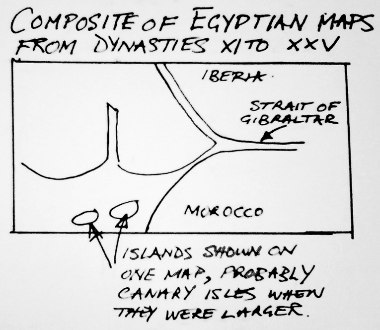
My theory is that the greater part of Atlantis, the huge southern plain described by Plato, now forms the seabed to the south of the coast in front of south-west Iberia and to the north of Morocco. Logic suggests that from early in the civilisation´s existence, North Morocco and the submerged area in front of it would have inevitably been annexed by the Atlanteans. At that time it would all have been very fertile and the narrow strait separating it from Gibraltar and Spain would have extended much further into the Atlantic and probably been even narrower than today. (See map)

It is clear from the bathymetric chart of the sea-floor that the area in front of the Algarve was once a large plain. It slopes very gradually, only a few metres or so per kilometre, but it is broken into three successive areas by what would appear to be ancient cliffs where the levels suddenly plunge by significant amounts. These sharp differences in levels could have been caused by combination of land suddenly sinking due to seismic events and the rise in sea-levels caused by the melting of ice-age glaciers. I know of at least one site of unidentified ruins which were exposed on the sea-floor when the ocean withdrew immediately before the tsunami of 1755 struck. Ancient river-beds are also clearly visible on the chart where many of the current rivers once extended as far as the extremity of the submerged plain, evidence that the whole area was once above water.

All of Plato´s other clues about climate, water, vegetation and crops identically match this region. Just one example, but a significant one, is that about the Atlantis countryside producing “a good store of chestnuts”. This rules out any tropical zone such as off the coast of central Africa, whereas South West Iberia has a bountiful crop every year.

Plato also wrote that Atlantis had a range of mountains immediately north of the great plain and the capital city. He indicates these mountains survived the disaster, although greatly diminished in size and number. They still exist today, starting inland immediately behind the remaining narrow coastal plain in the Algarve and extending eastwards across into Spain. After identifying that the region must be the Atlantis that Plato described, I searched the remaining countryside for any indications of sites of inland cities. Against all odds I found the actual site of the famous small capital that was described by Plato with such a surprising amount of very specific detail it is as though he wanted to make sure it could be identified. This site matches so many of those elements it is surely globally unique and quite beyond coincidence.

Here are just a few of the astonishing examples, all of which agree with Plato´s clues. It is connected to the sea by a tidal waterway of nine and a quarter kilometres, which is the exact distance specified; it is built on a small hill, itself on a small plain and the diametre of the hill, less than a kilometre, is still much as Plato indicated; it would have been only a couple of kilometres from the vast agricultural plain; the unusual combination of red, black and white stone could all have been quarried from this one small hill as detailed by Plato and used to build the city; remnants of the surrounding earth embankments, each originally separated by a ring of seawater, are in the correct positions on the west side. The outer one overlooks the ancient harbour, just as Plato specified. It was still a harbour in Phoenician and Roman times. You can see touch and verify them. It all represents a unique geological and geographical template. It is Silves, the ancient Moorish capital of Portugal´s Algarve and you can savour its atmosphere as you amble through the medieval streets and explore the awesome castle that exist on the site today.

Now, there only remains that big question mark. Was Plato reporting accurate facts about a lost civilisation or did he make up the story to achieve other ends? I think there is enough evidence to suggest Plato was certainly reporting a kernel of truth. The very fact that I think I have now established that Plato was talking about an exact area that once existed and had largely disappeared many thousands of years before his era, is strong proof in itself. How could he have known about it unless he had access to privileged information? Evidence is also laid out in the book to support Plato´s date of around 9,600 BC as being credible for the disappearance of Atlantis.

So, what next? There is much more in the book than briefly described here, including detail on the sprawling island empire stretching all the way to the Bahamas and Cuba. I hope the book will inspire exploration, particularly on the sea-bed as only then will we really know just how accurate Plato´s assertion was. If he was correct, apart from the ruins I know of, the whole sunken area would have been peppered with cities and ports. The sea-floor chart shows many clumps of “rocky areas” and “unknown obstructions”, could some of those be ruins of Atlantis stone buildings? Exploration will be fairly easy with modern equipment as the area is shallow, only slopes a few metres per kilometer and is flat.

Together with other discoveries now being made in Anatolia and the Far East, the next few years could prove very interesting with the possibility of revelations that will force a complete re-assessment of human civilised history.

Peter Daughtrey´s book, ATLANTIS and the Silver City, is published in the USA by Pegasus Books of New York as a hard-back edition and EBook, complete with 16 pages of colour photographs and many illustrations. It is available from bookshops and retail outlets or internationally from Amazon and other E retailers. In the UK it is published by Thistle of London as a paper-back and EBook, but only available direct from Amazon.

New Atlantis History channel documentary majors on the book.

I was approached in April to give an interview for a new documentary, “The hunt for Atlantis”, planned for the History channels. The producer had been alerted by one of the many favourable reviews followed by a visit to this website. I arranged for my publisher in America to send them a copy of the book and after reading it they became very enthusiastic.

A film crew flew over from Los Angeles at the end of May and we spent several days of intensive filming at sites I had recommended. The result was aired in America in late July and is now being rolled out in the UK and worldwide.

I am not entirely happy with it as although having about half the film, most of the vital important facts supporting my case have been left in the cutting room. I was also given the impression that I was taking part in a serious investigation about Atlantis but it appears the main agenda was aliens. The full title of the episode is  “In search of aliens. The hunt for Atlantis” Unfortunately the end of the film resembles sci-fi fantasy from a children ́s comic. But, I must not be churlish, I am very grateful to have my theories disseminated to a world­wide audience. You can watch it below and you will be able to see a little of Silves, the site indicated by Plato for the ancient capital, as well the great white stone egg.


In Search Of Aliens - S01E01 - The Hunt for... by Gogetassj415

The mystery of the submerged quay and fourty wrecks

I have recently unearthed information about a 400 metre stone-built quay that was discovered submerged around fourty years ago, just under a half a kilometre out from the Algarve shore. Strewn along it´s side were wrecks of fourty boats. The obvious explanation is that all the ships were destroyed in a catastrophic seismic upheaval involving a Tsunami together with the simultaneous plummeting of the seabed. The next year the shifting sands that had revealed the site had again engulfed it and nothing could be seen.

Samples of wood, bronze nails and ceramics were recovered by the sub-aqua club involved and were given to archaeologists who took them to Lisbon. Subsequently, the club heard nothing and there was no official announcement. Strange for such a spectacular discovery.

I suspect the authorities were baffled as my enquiries indicate the ceramics were earlier than Roman, which would have been the most obvious era. They might just have been from Tartessos which would support one of my theories advanced in the book, that this enigmatic kingdom was not just the small area around Cadiz, Huelva and Seville, but occupied the remnant of Atlantis all the way from Cadiz to the south west tip of the Algarve. One of the famous quotes about it in the Old Testament, from Isaiah 23:1, is, “Howl, ye ships of Tarshish for it is laid waste, so there is no house, no entering in.” It is broadly accepted that Tarshish and Tartessos are synonymous. This “laying waste” has been thought to refer to destruction by another power, but if my theory is correct it would more likely have been from a disastrous seismic event.

I doubt if any wrecks could have survived from the Atlantis era even if they had been buried in sand and mud. Nevertheless, it does add weight to my theory that is central to the book, that civilisations could have been destroyed in this region by successive, huge, catastrophic events.